


Montenegro is smaller than Connecticut. Yet it holds five national parks, peaks above 2,500 meters, and the deepest river canyon in Europe. Most hikers drive straight to the coast and never look up.
The real problem is planning. The trails exist Bobotov Kuk, the Lovćen mausoleum route, the 1,350-step fortress climb in Kotor but every guide buries them in generic lists with no distances, no entry fees, and no honest advice on timing.
This guide covers all three hiking regions in one place: Durmitor, Lovćen, and the Bay of Kotor with trail data, seasonal windows, and transport logistics so you can actually show up prepared.
QUICK ANSWER:
Montenegro’s best hiking spans three regions. Durmitor National Park offers alpine summits and glacial lakes near Žabljak. Lovćen pairs cultural history with Adriatic panoramas above Kotor. The Bay of Kotor delivers the famous 1,350-step fortress climb. Season runs May through October.
Why Montenegro Is Europe’s Best-Kept Hiking Secret
Montenegro’s trail network spans roughly 800 kilometers across five national parks alone. Here’s why hikers are catching on.
- Check the altitude — peaks reach 2,536 meters at Zla Kolata
- Pick from easy lakeside loops to multi-day alpine traversals
- Skip the crowds — trail traffic is a fraction of the Dolomites or Swiss Alps
- Use Žabljak, Kotor, or Podgorica as affordable base towns
- Choose between coastal Mediterranean trails and inland mountain terrain
The country also sits on two major long-distance routes. The Via Dinarica traverses the Dinaric Alps through five stages in Montenegro alone. The Peaks of the Balkans trail crosses the Prokletije range near the Albanian border. Both attract experienced trekkers seeking multi-day adventures.
Best Time to Hike in Montenegro
Timing matters because conditions vary dramatically between the coast and the mountains.
- Pick May through June for wildflowers and mild temperatures
- Avoid July and August on coastal trails — heat regularly exceeds 35°C
- Choose June through September for high-altitude Durmitor routes
- Check snow conditions before May in Durmitor — trails above 2,000 meters often stay snowbound until late spring
- Use September and October for ideal conditions across all regions
INSIDER SECRET: Mountain temperatures at Durmitor drop sharply after sunset, even in summer. Pack layers and at least one pair of long trousers — even if you’re only staying overnight in Žabljak.
Coastal hikes around the Bay of Kotor run from mid-April through late October. However, the shoulder months deliver the best combination of comfortable temperatures and fewer cruise-ship crowds.
Hiking Durmitor National Park
| Trail | Distance | Elevation Gain | Time | Difficulty |
|---|---|---|---|---|
| Bobotov Kuk Summit | ~16 km round trip | ~1,100 m | 7–8 hours | Hard |
| Black Lake Loop (Crno Jezero) | ~3.5 km loop | Minimal | 1–1.5 hours | Easy |
| Čurevac Viewpoint | ~2 km round trip | ~150 m | 2–3 hours | Easy–Moderate |
| Mount Prutaš (Southern Route) | ~10 km round trip | ~650 m | 5–6 hours | Moderate–Hard |
| Prutaš + Škrka Lakes Loop | ~14 km loop | ~750 m | 6–7 hours | Hard |
Durmitor is Montenegro’s flagship hiking destination. This UNESCO World Heritage site sits in the northwest, anchored by the gateway town of Žabljak. The park protects 18 glacial lakes, dense pine forests, and limestone peaks across the Dinaric Alps.
- Use Žabljak as your base — it’s walking distance to the park entrance
- Pay the entrance fee at the main gate near Black Lake (currently €5)
- Pick up the Cicerone “Mountains of Montenegro” guidebook for detailed route descriptions
- Check trail conditions at Hikers Den in Žabljak before heading out
- Drive the P14 scenic road between Žabljak and Plužine for trailhead access
From Kotor, Žabljak is roughly a three-hour drive. From Podgorica, it takes about two hours.
Bobotov Kuk — Montenegro’s Iconic Summit
Bobotov Kuk stands at 2,523 meters. It’s the highest peak in the Durmitor massif and the most popular summit hike in the park.
- Plan for 7–8 hours round trip from the standard trailhead
- Start early — afternoon thunderstorms are common above 2,000 meters
- Use the marked trail from Sedlo saddle or the Black Lake approach
- Check for lingering snow patches on the final ridge through June
The summit delivers panoramic views across the entire massif. On clear days, visibility extends into Bosnia and Herzegovina. This is a demanding hike that requires solid fitness and proper footwear.
Black Lake Loop (Crno Jezero)
Black Lake is the most accessible trail in Durmitor. The glacial lake sits just 10 minutes on foot from the park entrance near Žabljak.
- Walk the flat, paved path to reach the lakeshore
- Complete the full loop around both lake basins in about 90 minutes
- Use this trail as a warm-up day or a family-friendly option
- Start additional Durmitor hikes from the Black Lake trailhead
The forest-ringed lake reflects the surrounding peaks. It’s also the starting point for several longer routes deeper into the park.
Čurevac Viewpoint & Tara Canyon
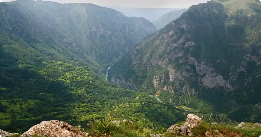
The Čurevac viewpoint hike rewards minimal effort with maximum impact. Tara Canyon reaches a maximum depth of 1,333 meters — the deepest river canyon in Europe.
- Drive north from Žabljak toward Nadgora to reach the trailhead (about 20 minutes)
- Hike roughly 1 kilometer one-way along the canyon rim
- Expect rocky, uneven terrain — wear proper hiking shoes
- Allow 2–3 hours round trip including time at the viewpoint
The trail follows the cliff edge with continuous views into the gorge. Because the approach is short, this pairs well with a half-day of rafting on the Tara River below.
Mount Prutaš & Škrka Lakes
Mount Prutaš is visible from the Durmitor Ring Road. Its distinctive layered rock formation makes it one of the park’s most photographed peaks.
- Choose the easier southern approach from Dobri Do/Šarban trailhead
- Skip the western route from Todorov Do unless you’re experienced — it’s significantly steeper
- Combine with a descent to the Škrka Lakes for a full-day loop
- Allow 5–6 hours for the combined Prutaš summit and lakes circuit
The Škrka Lakes sit in a remote glacial valley below Prutaš. These two connected lakes see far fewer visitors than Black Lake.
Durmitor Ring Road Trailheads
The P14 road connecting Žabljak to Plužine passes multiple marked trailheads. A rental car opens access to routes that public transport can’t reach.
- Use the Todorov Do trailhead for western approaches to Prutaš and the Škrka Lakes
- Access Dobri Do/Šarban for the easier southern route options
- Stop at the scenic viewpoint frames positioned along the road for photos
- Fill up on fuel in Žabljak — services are limited along the P14
If you don’t have a car, local taxis from Žabljak can drop you at most trailheads. Negotiate the fare and pickup time before setting out.
Hiking Lovćen National Park
| Trail | Distance | Elevation Gain | Time | Difficulty |
|---|---|---|---|---|
| Njegoš Mausoleum (from Ivanova Korita) | ~11 km round trip | ~400 m | 3–4 hours | Moderate–Hard |
| Wolf Trail (Vučji Put) | ~7 km loop | Minimal | 3–4 hours | Easy |
| Kotor to Lovćen (Full Ascent) | ~15 km one way | ~1,600 m | 6–8 hours | Very Hard |
| Mausoleum Steps (from parking lot) | 461 steps | ~58 m | 20–30 min | Easy |
Lovćen National Park sits in southwestern Montenegro, rising steeply from the Adriatic coast above Kotor. The park covers 6,220 acres of karst limestone terrain. Its highest peak, Štirovnik, reaches 1,749 meters.
- Drive from Kotor or Budva in roughly one hour via the P1 serpentine road
- Take the Kotor–Lovćen cable car for an 11-minute scenic ascent (currently €23)
- Use Ivanova Korita as your trailhead base within the park
- Expect temperatures 10°C cooler than the coast — pack a light jacket
Lovćen is where Montenegro gets its name. “Crna Gora” means “black mountain” in Montenegrin, a reference to the dark forests covering these slopes.
Njegoš Mausoleum Trail from Ivanova Korita
The hike from Ivanova Korita to the Njegoš Mausoleum is Lovćen’s signature route. The mausoleum sits atop Jezerski Vrh at 1,657 meters.
- Cover roughly 11 kilometers round trip with over 400 meters of elevation gain
- Allow 3–4 hours for the full hike plus time at the mausoleum
- Climb 461 final stone steps from the parking area to the mausoleum entrance
- Pay the mausoleum entry fee (currently €8)
The mausoleum honors Petar II Petrović-Njegoš, Montenegro’s most revered historical figure. The circular viewing platform behind the tomb delivers views across the Bay of Kotor, the Adriatic Sea, and — on clear days — as far as Albania and Croatia. The last section of trail is steep and exposed. Start early in summer to avoid midday heat.
The Wolf Trail (Vučji Put)
The Wolf Trail is Lovćen’s most accessible hiking option. It loops through beech forest with minimal elevation change.
- Start from the visitor center at Ivanova Korita
- Complete the 7-kilometer loop in 3–4 hours
- Enjoy shaded forest walking for most of the route
- Reach the Kraljevo Počivalo lookout for coastal panoramas
This trail works well for families or as a recovery day between harder hikes. Additionally, the visitor center rents mountain bikes for €2 per hour if you want to explore on wheels.
Kotor to Lovćen — The Full Mountain Ascent
For experienced hikers, the old packhorse trail from Kotor climbs all the way to the Lovćen ridgeline.
- Start from the Kotor fortress or the Ladder of Kotor trail
- Allow a full day for the ascent — the route is steep with limited shade
- Gain over 1,600 meters of elevation from sea level to the mausoleum
- Avoid this route entirely during July and August heat
This is the hardest day hike in the Kotor region. However, the reward is hiking the same route that connected coastal Kotor with the mountain village of Njeguši for centuries.
Hiking Kotor & the Bay of Kotor
| Route | Steps / Distance | Elevation Gain | Time | Entry Fee | Difficulty |
|---|---|---|---|---|---|
| Kotor Fortress (San Giovanni) | ~1,350 steps / 2.5 km | 254 m | 1.5–2 hours | €15 | Moderate |
| Ladder of Kotor (Cattaro) | ~13 km round trip | ~1,000 m | 3–4 hours | Free (€15 if exiting via fortress) | Hard |
The Bay of Kotor delivers Montenegro’s most accessible hikes. Every cruise ship passenger and road-tripper can reach these trails on foot from the Old Town.
- Start from Kotor’s UNESCO-listed Old Town for both main routes
- Check trail opening hours — the fortress path operates 8 AM to 10 PM
- Carry water — there are no refill stations on either route
- Wear proper shoes — stone steps get slippery, especially after rain
Kotor Fortress (San Giovanni) Climb
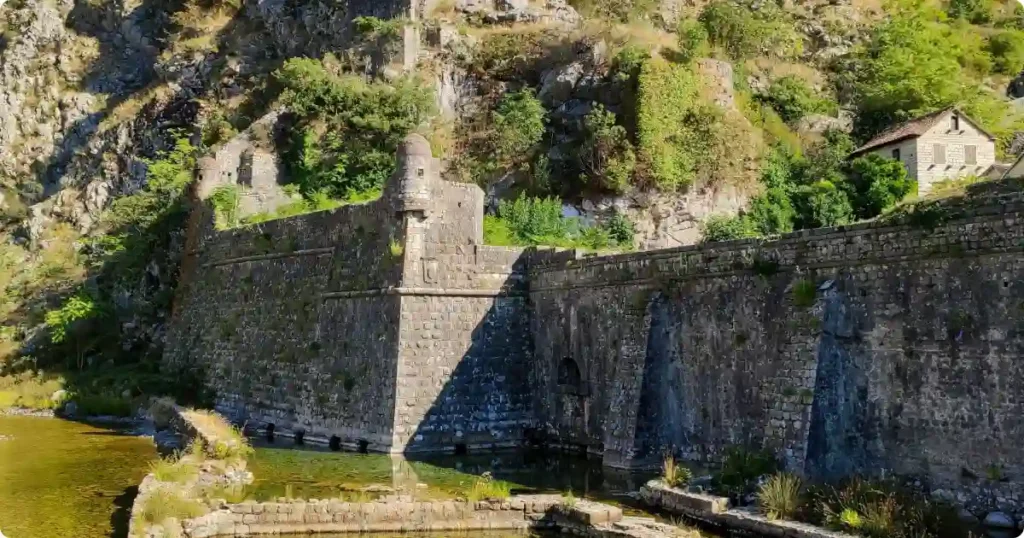
The Kotor fortress hike is Montenegro’s single most popular trail. Roughly 1,350 stone steps climb 254 meters to the ruins of San Giovanni fortress.
- Allow 1.5–2 hours round trip at a moderate pace
- Pay the entrance fee (currently €15) at the booth near the Old Town
- Pass the 16th-century Church of Our Lady of Remedy at the halfway point
- Reach the fortress ruins for 360-degree views over the bay and Old Town
The path zigzags along medieval city walls built primarily during Venetian rule. The entire defensive complex is a UNESCO World Heritage site. Start early in summer — the exposed stone steps become punishing in afternoon heat. The second half above the church is steeper and narrower.
The Ladder of Kotor (Ladder of Cattaro)
The Ladder of Kotor is the historic switchback trail that once connected Kotor to Njeguši village inland. It runs parallel to the fortress route but climbs much higher.
- Budget 3–4 hours round trip for a partial ascent
- Pick up the trailhead near the fortress path and follow red-and-white markings
- Detour to the Chapel of St. Ivan and the back of San Giovanni fortress
- Bring €15 cash — you may be charged the fortress fee when exiting through the lower route
This trail climbs through true mountain terrain above the bay. Because the Ladder continues upward toward Lovćen, it’s possible to connect all the way to the mausoleum — though that requires a full-day commitment and serious fitness.
What to Pack for Hiking in Montenegro
Montenegro’s trails shift from Mediterranean coast to alpine terrain within a two-hour drive. Pack accordingly.
- Use sturdy hiking shoes with good grip — stone steps and rocky trails are the norm
- Carry at least 2 liters of water per person — mountain refill points are rare
- Pack sun protection for coastal hikes — sunscreen, hat, and sunglasses
- Bring layers for Durmitor — temperatures drop sharply after sunset
- Download offline maps — mobile signal is unreliable on mountain trails
Montenegro uses the euro. ATMs are available in Kotor, Žabljak, Cetinje, and Podgorica. However, smaller trailhead parking areas and mountain huts may be cash-only.
Getting Around: Logistics & Transport
A rental car is the most practical way to reach Montenegro’s hiking trailheads. Public transport exists but limits your flexibility.
- Rent a car for Durmitor access — the P14 Ring Road requires your own vehicle
- Use the Kotor–Lovćen cable car to eliminate the serpentine drive
- Take a bus from Podgorica to Žabljak if you’re traveling without a car
- Rely on local taxis from Žabljak to reach trailheads beyond walking distance
- Drive cautiously on the P1 serpentine — 25 hairpin turns above the Bay of Kotor
Montenegro’s national park pass covers all five parks. If you plan to visit Durmitor and Lovćen on the same trip, the annual pass saves money compared to individual tickets.
The Verdict
I rate Montenegro as one of Europe’s most undervalued hiking destinations. Durmitor delivers genuine alpine drama without the Alps price tag. Lovćen offers cultural depth that most mountain parks can’t match. Meanwhile, the Kotor fortress climb packs a lifetime highlight into 90 minutes.
The country works best as a two-region trip. Spend three to four days in Durmitor for mountain trails. Then move south for Lovćen and the Bay of Kotor coast. September timing nails both regions.
Montenegro’s trails are still relatively quiet. That won’t last. Go now.
